
Kapama Game Reserve topographic map
Interactive map
Click on the map to display elevation.
About this map
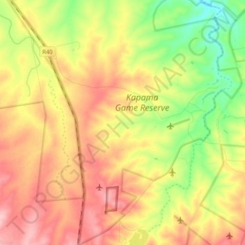
Name: Kapama Game Reserve topographic map, elevation, terrain.
Average elevation: 544 m
Minimum elevation: 466 m
Maximum elevation: 619 m
Other topographic maps
Click on a map to view its topography, its elevation and its terrain.
Olifants River
RSA > Limpopo > Maruleng Local Municipality
Olifants River, Maruleng Local Municipality, Mopani District Municipality, Limpopo, RSA
Average elevation: 373 m
Thornybush Game Reserve
RSA > Limpopo > Maruleng Local Municipality
Thornybush Game Reserve, Way to Thornybush Waterside Lodge, Maruleng Ward 1, Maruleng Local Municipality, Mopani District Municipality, Limpopo, RSA
Average elevation: 514 m
Blyde Nature Reserve
RSA > Limpopo > Maruleng Local Municipality
Blyde Nature Reserve, Maruleng Ward 2, Maruleng Local Municipality, Mopani District Municipality, Limpopo, RSA
Average elevation: 744 m
Umhlametsi Game Reserve
RSA > Limpopo > Maruleng Local Municipality
Umhlametsi Game Reserve, Maruleng Ward 1, Maruleng Local Municipality, Mopani District Municipality, Limpopo, RSA
Average elevation: 471 m