
Ganderbal topographic map
Interactive map
Click on the map to display elevation.
About this map
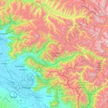
Name: Ganderbal topographic map, elevation, terrain.
Location: Ganderbal, Jammu and Kashmir, India (34.11863 74.65815 34.46354 75.49873)
Average elevation: 3,086 m
Minimum elevation: 1,576 m
Maximum elevation: 5,416 m
Other topographic maps
Click on a map to view its topography, its elevation and its terrain.
Gund Sadarkote
India > Jammu and Kashmir > Gund Sadarkote
Gund Sadarkote, Sonawari, Bandipore District, Jammu and Kashmir, 193504, India
Average elevation: 1,651 m
Ganderbal
India > Jammu and Kashmir > Ganderbal
Ganderbal, Lar, Ganderbal District, Jammu and Kashmir, 191131, India
Average elevation: 1,648 m
Sonamarg
India > Jammu and Kashmir > Sonamarg
Sonamarg, Ganderbal, Jammu and Kashmir, India
Average elevation: 3,354 m
Nun
Nun, Kargil District, Jammu and Kashmir, India
Average elevation: 5,988 m
Siachen Glacier
Siachen Glacier, Leh District, Jammu and Kashmir, India
Average elevation: 5,448 m
Central Chong Kumdan Glacier
Central Chong Kumdan Glacier, Leh District, Jammu and Kashmir, India
Average elevation: 5,823 m
South Rimo Glacier
South Rimo Glacier, Leh District, Jammu and Kashmir, India
Average elevation: 5,595 m