
Mossel Bay topographic map
Interactive map
Click on the map to display elevation.
About this map
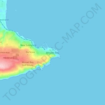
Name: Mossel Bay topographic map, elevation, terrain.
Location: Mossel Bay, George, Western Cape, 6506, South Africa (-34.22320 22.11362 -34.14320 22.19362)
Average elevation: 16 m
Minimum elevation: -2 m
Maximum elevation: 192 m
To the east, the land slopes upwards towards the wave-cut platform (average elevation 245 metres) that characterises the more lush all-year-round rainfall area of the Garden Route. Here the land is mostly covered by grass and farmlands. The deep sandy soils of the western portion of the municipal area also give way to grass and farm-lands, with large stands of typically dry fynbos which are characterised by, amongst others, the Aloe ferox (also known as the bitter aloe, Cape aloe or red aloe) from which skin-care products are made locally, and the Chondropetalum tectorum (Cape or thatching reed) which is used for the roofing of traditional Cape-Dutch buildings.
Other topographic maps
Click on a map to view its topography, its elevation and its terrain.
Groot-Brakrivier
South Africa > Western Cape > George
Groot-Brakrivier, Mossel Bay Local Municipality, George, Western Cape, South Africa
Average elevation: 95 m
Map of Africa
South Africa > Western Cape > George
Map of Africa, Remskoen, George Local Municipality, George, Western Cape, 6560, South Africa
Average elevation: 80 m
Kurland
South Africa > Western Cape > George
Kurland, George, Western Cape, 6602, South Africa
Average elevation: 226 m
Herolds Bay
South Africa > Western Cape > George
Herolds Bay, George Ward 23, George Local Municipality, George, Western Cape, South Africa
Average elevation: 105 m
Geelhoutboom
South Africa > Western Cape > George
Geelhoutboom, George Ward 22, George Local Municipality, George, Western Cape, South Africa
Average elevation: 250 m
Reebok
South Africa > Western Cape > George
Reebok, George, Western Cape, 6503, South Africa
Average elevation: 30 m
Stilbaai
South Africa > Western Cape > George
Stilbaai, George, Western Cape, South Africa
Average elevation: 57 m
Oudtshoorn
South Africa > Western Cape > George
Oudtshoorn, Oudtshoorn Local Municipality, George, Western Cape, South Africa
Average elevation: 354 m
Oudtshoorn Local Municipality
South Africa > Western Cape > George
Oudtshoorn Local Municipality, George, Western Cape, South Africa
Average elevation: 636 m
Witsand
South Africa > Western Cape > George
Witsand, George, Western Cape, 6666, South Africa
Average elevation: 39 m
Heidelberg
South Africa > Western Cape > George
Heidelberg, George, Western Cape, South Africa
Average elevation: 146 m