
Langley topographic map
Interactive map
Click on the map to display elevation.
About this map
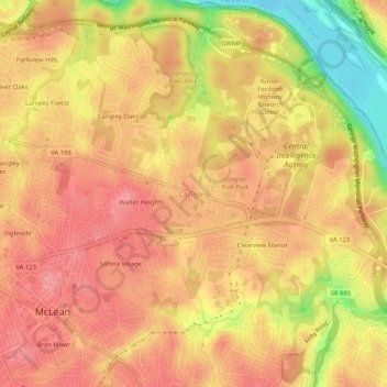
Name: Langley topographic map, elevation, terrain.
Location: Langley, Fairfax County, Virginia, 22101, United States (38.92650 -77.17887 38.96650 -77.13887)
Average elevation: 70 m
Minimum elevation: 7 m
Maximum elevation: 99 m
Other topographic maps
Click on a map to view its topography, its elevation and its terrain.
Chantilly
United States > Virginia > Fairfax County
Chantilly, Fairfax County, Virginia, United States
Average elevation: 96 m
Cooktown
United States > Virginia > Fairfax County > Herndon
Cooktown, Herndon, Fairfax County, Virginia, 20170, United States
Average elevation: 105 m