
Yungay topographic map
Interactive map
Click on the map to display elevation.
About this map
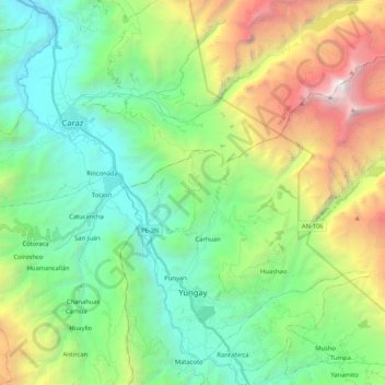
Name: Yungay topographic map, elevation, terrain.
Location: Yungay, Province of Yungay, Ancash, Peru (-9.17868 -77.78294 -8.99381 -77.57379)
Average elevation: 3,365 m
Minimum elevation: 2,079 m
Maximum elevation: 6,363 m
The Cordillera Blanca traverses the province. Waskaran, the highest elevation of Peru, lies on the border to the Carhuaz Province. Other mountains are listed below: