
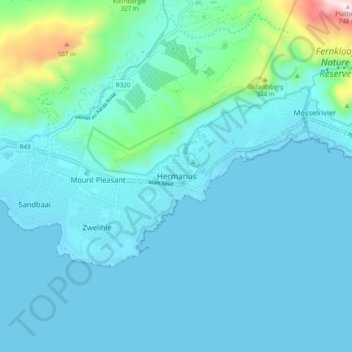
Hermanus topographic map
Interactive map
Click on the map to display elevation.
About this map
Name: Hermanus topographic map, elevation, terrain.
Average elevation: 87 m
Minimum elevation: -1 m
Maximum elevation: 743 m
Other topographic maps
Click on a map to view its topography, its elevation and its terrain.
Gansbaai
South Africa > Western Cape > Overstrand Local Municipality
Gansbaai, Overstrand Local Municipality, Western Cape, South Africa
Average elevation: 34 m
Onrus River
South Africa > Western Cape > Overstrand Local Municipality
Onrus River, Overstrand Local Municipality, Western Cape, South Africa
Average elevation: 232 m
Betty's Bay
South Africa > Western Cape > Overstrand Local Municipality
Betty's Bay, Overstrand Local Municipality, Western Cape, 7141, South Africa
Average elevation: 210 m
Stanford
South Africa > Western Cape > Overstrand Local Municipality
Stanford, Overstrand Local Municipality, Western Cape, 7210, South Africa
Average elevation: 107 m
Boskop
South Africa > Western Cape > Overstrand Local Municipality
Boskop, Overstrand Local Municipality, Overberg District Municipality, Western Cape, 7210, South Africa
Average elevation: 503 m
Three Sisters
South Africa > Western Cape > Overstrand Local Municipality
Three Sisters, Overstrand Local Municipality, Overberg District Municipality, Western Cape, 7195, South Africa
Average elevation: 306 m
Kleinmond
South Africa > Western Cape > Overstrand Local Municipality
Kleinmond, Overstrand Local Municipality, Western Cape, 7195, South Africa
Average elevation: 119 m