
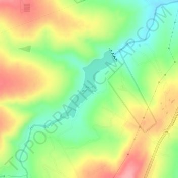
Cradle Moon Lake topographic map
Interactive map
Click on the map to display elevation.
About this map
Name: Cradle Moon Lake topographic map, elevation, terrain.
Average elevation: 1,372 m
Minimum elevation: 1,314 m
Maximum elevation: 1,428 m
Other topographic maps
Click on a map to view its topography, its elevation and its terrain.
Rietvallei 241-IQ
South Africa > Gauteng > West Rand District Municipality > Mogale City Local Municipality
Rietvallei 241-IQ, Mogale City Local Municipality, West Rand District Municipality, Gauteng, 1754, South Africa
Average elevation: 1,684 m
Magaliesburg
South Africa > Gauteng > West Rand District Municipality > Mogale City Local Municipality
Magaliesburg, Mogale City Local Municipality, West Rand District Municipality, Gauteng, 1791, South Africa
Average elevation: 1,504 m
Magalies
South Africa > Gauteng > West Rand District Municipality > Mogale City Local Municipality
Magalies, Mogale City Local Municipality, West Rand District Municipality, Gauteng, South Africa
Average elevation: 1,434 m
Muldersdrift
South Africa > Gauteng > West Rand District Municipality > Mogale City Local Municipality
Muldersdrift, Mogale City Local Municipality, West Rand District Municipality, Gauteng, 1747, South Africa
Average elevation: 1,449 m
Hekpoort
South Africa > Gauteng > West Rand District Municipality > Mogale City Local Municipality
Hekpoort, Mogale City Local Municipality, West Rand District Municipality, Gauteng, South Africa
Average elevation: 1,278 m