
East Delhi topographic map
Interactive map
Click on the map to display elevation.
About this map
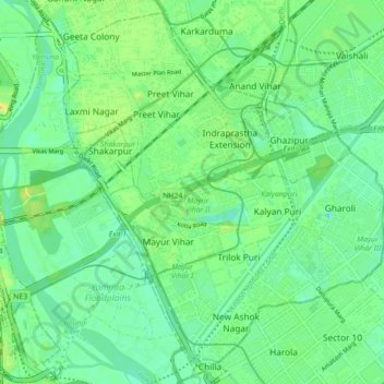
Name: East Delhi topographic map, elevation, terrain.
Location: East Delhi, Delhi, India (28.58256 77.25423 28.65706 77.34201)
Average elevation: 205 m
Minimum elevation: 195 m
Maximum elevation: 220 m
Other topographic maps
Click on a map to view its topography, its elevation and its terrain.
Coronation Park
India > Delhi > Model Town Tehsil
Coronation Park, Model Town Tehsil, North Delhi District, Delhi, India
Average elevation: 209 m
Rajouri Garden Tehsil
Rajouri Garden Tehsil, West Delhi, Delhi, India
Average elevation: 218 m