
Make a donation
Lake Michigan topographic map
Click on the map to display elevation.
Make a donation
Lake Michigan
Lake Michigan is one of the five Great Lakes of North America. It is the second-largest of the Great Lakes by volume (1,180 cu mi (4,900 km3)) and the third-largest by surface area (22,404 sq mi (58,030 km2)), after Lake Superior and Lake Huron. To the east, its basin is conjoined with that of Lake Huron through the 3+1⁄2 miles (5.6 kilometers) wide, 295 feet (90 meters; 49 fathoms) deep, Straits of Mackinac, giving it the same surface elevation as its easterly counterpart; the two are technically a single lake.
Make a donation
About this map
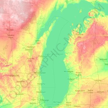
Name: Lake Michigan topographic map, elevation, terrain.
Location: Lake Michigan, United States (41.60887 -88.04169 46.10229 -84.75193)
Average elevation: 260 m
Minimum elevation: 169 m
Maximum elevation: 582 m
Make a donation
Other topographic maps
Click on a map to view its topography, its elevation and its terrain.
Flagstaff
United States > Arizona > Coconino County
Flagstaff, located in Coconino County, Arizona, is characterized by its diverse topography, primarily shaped by its high elevation and volcanic activity. Sitting at around 7,000 feet (approximately 2,130 meters), the city is surrounded by the expansive Coconino National Forest, which features a blend of…
Average elevation: 2,176 m
Baltimore
Baltimore exhibits a diverse topography that plays a significant role in its character and development. Situated along the Patapsco River, which flows into the Chesapeake Bay, the city is positioned on the fall line that separates the Piedmont Plateau to the west from the Atlantic Coastal Plain to the east.…
Average elevation: 65 m
Tucson
United States > Arizona > Pima County > Tucson
The city's elevation is 2,643 ft (806 m) above sea level (as measured at the Tucson International Airport). Tucson is on an alluvial plain in the Sonoran Desert, surrounded by five minor ranges of mountains: the Santa Catalina Mountains and the Tortolita Mountains to the north, the Santa Rita Mountains to the…
Average elevation: 836 m
Make a donation
Yucca Valley
United States > California > San Bernardino County
Yucca Valley lies in the middle of the Morongo Basin at a base elevation of 3,300 feet. Joshua Tree National Park is adjacent to its southern border.
Average elevation: 1,106 m
Hudson
United States > Florida > Hudson
Hudson features a predominantly flat and low-lying topography typical of the region, with an average elevation of approximately 16 feet above sea level. This terrain is interspersed with various wetlands and small lakes, creating a rich ecosystem that supports diverse wildlife. The area also includes a few…
Average elevation: 5 m
Make a donation
Blue Ridge
United States > Virginia > Loudoun County
Blue Ridge Mountain is noticeably lower in elevation than other sections of the Blue Ridge Mountains in Virginia. The southern section of the mountain contains the highest peaks, and the ridge gradually loses elevation as it gets closer to the Potomac. Elevations in the gaps are typically around 1,000 feet…
Average elevation: 183 m
Austin
United States > Texas > Travis County
The elevation of Austin varies from 425 feet (130 m) to approximately 1,000 feet (305 m) above sea level. Due to the fact it straddles the Balcones Fault, much of the eastern part of the city is flat, with heavy clay and loam soils, whereas the western part and western suburbs consist of rolling hills on the…
Average elevation: 203 m
Make a donation
Virginia Beach
United States > Virginia > Virginia Beach
Virginia Beach, Virginia, located in the coastal region of the United States, features a predominantly flat terrain characterized by its proximity to the Atlantic Ocean. The elevation is remarkably low, averaging about 10 feet (3 meters) above sea level, which contributes to the area's susceptibility to…
Average elevation: 2 m
Fairbanks
United States > Alaska > Fairbanks North Star
Fairbanks is situated within the central Tanana Valley, characterized by a diverse and dynamic topography. The city straddles the Chena River, which flows southwest into the larger Tanana River, defining Fairbanks' southern border. To the north, a gradual incline leads into a chain of hills that ascend toward…
Average elevation: 146 m
Make a donation
highest point in Warren County PA
United States > Pennsylvania > Warren County
Average elevation: 622 m
Make a donation
Saint Paul
United States > Minnesota > Ramsey County > Saint Paul
The year 1858 saw more than 1,000 steamboats service Saint Paul, making it a gateway for settlers to the Minnesota frontier or Dakota Territory. Geography was a primary reason the city became a transportation hub. The location was the last good point to land riverboats coming upriver due to the river valley's…
Average elevation: 273 m
Mount Rushmore
Mount Rushmore National Memorial is centered on a colossal sculpture carved into the granite face of Mount Rushmore (Lakota Tȟuŋkášila Šákpe, or Six Grandfathers) in the Black Hills in Keystone, South Dakota. Sculptor Gutzon Borglum created the sculpture's design and oversaw the project's execution from…
Average elevation: 1,562 m
Make a donation
Franklin Mountains State Park
United States > Texas > El Paso County > El Paso
Franklin Mountains State Park is a Texas state park in El Paso, Texas, that protects the Franklin Mountains. Park headquarters are located at an elevation of 5,426 feet (1,654 m) with the highest peak, North Franklin Mountain, reaching 7,192 feet (2,192 m). It is one of the largest urban parks in the nation…
Average elevation: 1,293 m
Make a donation
Shaver Lake
United States > California > Fresno County
Shaver Lake (formerly, Musick Creek and Musick Creek Heights) is a census-designated place (CDP) in Fresno County, California, United States. The population was 634 at the 2010 census, down from 705 at the 2000 census. Shaver Lake is on the southwest end of the lake of the same name, 10 miles (16 km) east of…
Average elevation: 1,563 m
San Gorgonio Pass
United States > California > Riverside County
The San Gorgonio Pass, or Banning Pass, is a 2,600 ft (790 m) elevation gap on the rim of the Great Basin between the San Bernardino Mountains to the north and the San Jacinto Mountains to the south. The pass was formed by the San Andreas Fault, a major transform fault between the Pacific plate and the North…
Average elevation: 492 m
Evanston
United States > Wyoming > Uinta County > Evanston
Evanston is located at 41°15′48″N 110°57′53″W / 41.26333°N 110.96472°W / 41.26333; -110.96472 (41.263302, −110.964616). The elevation is 6749 feet (2057 m) above sea level.
Average elevation: 2,157 m
Make a donation
Make a donation
Boise
United States > Idaho > Ada County
Boise (locally /ˈbɔɪsi/ BOY-see) is the capital and most populous city of the U.S. state of Idaho and is the county seat of Ada County. As of the 2020 census, there were 235,684 people residing in the city. On the Boise River in southwestern Idaho, it is 41 miles (66 km) east of the Oregon border and 110…
Average elevation: 1,040 m
Seligman
United States > Arizona > Yavapai County > Seligman
Seligman is located at 35°19′42″N 112°52′27″W / 35.32833°N 112.87417°W / 35.32833; -112.87417 (35.328199, −112.874303), at 5,240 feet (1,600 m) in elevation, alongside the Big Chino Wash, in a northern section of Chino Valley. The wash is a major tributary of the Verde River. Seligman is…
Average elevation: 1,617 m
Make a donation
Thousand Oaks
United States > California > Ventura County > Thousand Oaks
The northern parts consist of mountainous terrain in the Simi Hills, Conejo Mountains and Mount Clef Ridge. Narrow canyons such as Hill Canyon cut through the steeper mountainous areas. Conejo Mountain and Conejo Grade are found in westernmost Newbury Park, while the southernmost parts of Thousand Oaks are…
Average elevation: 303 m
Make a donation
Phoenix
United States > Arizona > Maricopa County > Phoenix
Phoenix is in the south-central portion of Arizona; about halfway between Tucson to the southeast and Flagstaff to the north, in the southwestern United States. By car, the city is approximately 150 miles (240 kilometers) north of the US–Mexico border at Sonoyta and 180 mi (290 km) north of the border at…
Average elevation: 368 m
Make a donation
Wake Island
On November 1, 2015, a complex $230 million U.S. military missile defense system test event, called Campaign Fierce Sentry Flight Test Operational-02 Event 2 (FTO-02 E2), was conducted at Wake Island and the surrounding ocean areas. The test involved a Terminal High Altitude Area Defense (THAAD) system built…
Average elevation: 1 m
Make a donation
Diamondhead
United States > Mississippi > Hancock County
Much of the land that became Diamondhead had been purchased by Walter Gex, Sr., in 1937 from the Gulf State Paper Company and the Easy Opener Bag Company. Additional land was purchased by Gex, bringing his acquisition to nearly 5,000 acres (2,000 ha). In the late 1960s, D.E.A.R., Inc., later known as the…
Average elevation: 3 m
Make a donation
Troy
United States > New York > Rensselaer County
The western edge of the city is flat along the river, and then steeply slopes to higher terrain to the east. The average elevation is 50 feet, with the highest elevation being 500 feet in the eastern part of the city. The city is longer than it is wide, with the southern part wider than the northern section of…
Average elevation: 137 m
Make a donation
Shelby Charter Township
United States > Michigan > Shelby Charter Township > Shelby
Average elevation: 205 m
Pinetop-Lakeside
United States > Arizona > Navajo County
Pinetop-Lakeside is nestled in the stunning White Mountains of northeastern Arizona, characterized by a varied topography that significantly influences its natural beauty and recreational opportunities. The terrain features elevations averaging around 6,795 feet, with rugged mountain landscapes interspersed…
Average elevation: 2,087 m
South Pass
United States > Wyoming > Fremont County
South Pass (elevation 7,412 ft (2,259 m) and 7,550 ft (2,300 m)) is a route across the Continental Divide, in the Rocky Mountains in southwestern Wyoming. It lies in a broad high region, 35 miles (56 km) wide, between the nearly 14,000 ft (4,300 m) Wind River Range to the north and the over 8,500 ft (2,600 m)…
Average elevation: 2,295 m
Make a donation
Mystic Islands
United States > New Jersey > Ocean County > Little Egg Harbor Township
Average elevation: 1 m
Make a donation
Stuyvesant Falls
United States > New York > Columbia County > Town of Stuyvesant
Average elevation: 58 m
Make a donation
Los Angeles River
United States > California > Los Angeles County > Los Angeles
Average elevation: 243 m
Make a donation
Cincinnati
United States > Ohio > Hamilton County
Cincinnati has several standard modes of transportation including sidewalks, roads, public transit, bicycle paths and airports. The city's hills preclude the regular street grid common to many cities built up in the 19th century, and outside of the downtown basin, regular street grids are rare except for in…
Average elevation: 225 m
Olde Georgetowne
United States > North Carolina > Mecklenburg County > Charlotte
Average elevation: 194 m
Make a donation
Brooktrails
United States > California > Mendocino County
Brooktrails is in central Mendocino County, occupying hills to the west of Little Lake Valley. The fire department and golf course lie at an elevation of 1,634 feet (498 m), but the community's western edge rises to nearly 3,000 feet (910 m). It is 3 miles (5 km) north of Willits. According to the United…
Average elevation: 569 m
Make a donation
Make a donation
Port Washington
United States > Wisconsin > Ozaukee County > Port Washington > Port Washington
Average elevation: 205 m
Make a donation
Make a donation
Lafayette
United States > Louisiana > Lafayette Parish > Lafayette
Lafayette lies approximately 135 miles (217 km) from New Orleans, 59 miles (95 km) from the state capital of Baton Rouge, 75 miles (121 km) from Lake Charles, and 89 miles (143 km) from Alexandria. The city has an elevation ranging from 36 feet (11.0 m) to 49 feet (15 m) above sea level. According to the…
Average elevation: 9 m
Make a donation