
Krom topographic map
Interactive map
Click on the map to display elevation.
About this map
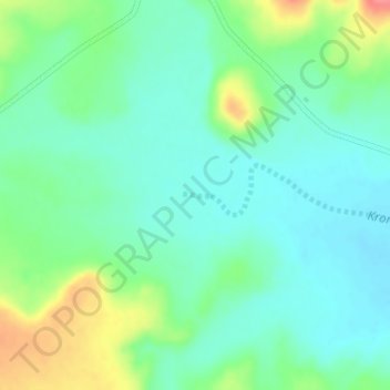
Name: Krom topographic map, elevation, terrain.
Average elevation: 1,372 m
Minimum elevation: 1,350 m
Maximum elevation: 1,423 m
Other topographic maps
Click on a map to view its topography, its elevation and its terrain.
Buffelsrivier
RSA > Western Cape > Beaufort West Local Municipality
Buffelsrivier, Beaufort West Local Municipality, Central Karoo District Municipality, Western Cape, RSA
Average elevation: 1,075 m
Renosterkop Dam
RSA > Western Cape > Beaufort West Local Municipality
Renosterkop Dam, Beaufort West Local Municipality, Central Karoo District Municipality, Western Cape, RSA
Average elevation: 988 m