
Thank you for supporting this site ❤️
Make a donation
Make a donation
Hessisch Lichtenau topographic map
Click on the map to display elevation.
Thank you for supporting this site ❤️
Make a donation
Make a donation
About this map
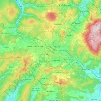
Name: Hessisch Lichtenau topographic map, elevation, terrain.
Average elevation: 416 m
Minimum elevation: 236 m
Maximum elevation: 761 m
Thank you for supporting this site ❤️
Make a donation
Make a donation
Other topographic maps
Click on a map to view its topography, its elevation and its terrain.
Giesenberg
Duitsland > Hessen > Werra-Meißner-Kreis > Gutsbezirk Kaufunger Wald
Average elevation: 473 m