
Make a donation
Mutasa topographic map
Click on the map to display elevation.
Make a donation
About this map
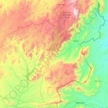
Name: Mutasa topographic map, elevation, terrain.
Location: Mutasa, Manicaland Province, Zimbabwe (-18.97345 32.39750 -18.20112 33.06835)
Average elevation: 1,262 m
Minimum elevation: 531 m
Maximum elevation: 2,565 m
Make a donation
Other topographic maps
Click on a map to view its topography, its elevation and its terrain.
Mutare
Zimbabwe > Manicaland Province > Mutare
Despite its tropical location, the city has a humid subtropical climate, of the highland variety moderated by its altitude. Mutare experiences drizzle almost throughout the year. The average annual temperature is 19 °C, surprisingly low for its moderate altitude (about the same as Harare which is 360 metres…
Average elevation: 1,160 m
Make a donation
Mutare
Zimbabwe > Manicaland Province > Mutare
Despite its subtropical location, the city has a humid subtropical climate, of the highland variety moderated by its altitude. Mutare experience drizzle almost throughout the year. The average annual temperature is 19 °C, surprisingly low for its moderate altitude (about the same as Harare which is 360 metres…
Average elevation: 1,160 m
Make a donation
Mutare
Zimbabwe > Manicaland Province > Mutare
Despite its subtropical location, the city has a humid subtropical climate, of the highland variety moderated by its altitude. The average annual temperature is 19 °C, surprisingly low for its moderate altitude (about the same as Harare which is 360 metres higher.) This is due to its sheltered position…
Average elevation: 1,160 m