
Mersch topographic map
Interactive map
Click on the map to display elevation.
About this map
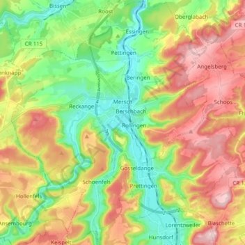
Name: Mersch topographic map, elevation, terrain.
Location: Mersch, Canton Mersch, Luxembourg (49.69306 6.03732 49.79127 6.15897)
Average elevation: 311 m
Minimum elevation: 211 m
Maximum elevation: 438 m
Mersch est nommé Marisch en 853. Ce nom proviendrait selon une source de Marcius + acum (c'est-à-dire le domaine de Marcius). Selon une autre source plus en accord avec sa situation topographique en plaine, le nom de cette agglomération serait dérivé du terme latin marisca, qui désigne un marécage.
Other topographic maps
Click on a map to view its topography, its elevation and its terrain.
Reckange
Reckange, Mersch, Canton Mersch, 7595, Luxembourg
Average elevation: 271 m
Hollenfels
Luxembourg > Canton Mersch > Helperknapp
Hollenfels, Helperknapp, Canton Mersch, 7435, Luxembourg
Average elevation: 327 m