
Aljezur topographic map
Interactive map
Click on the map to display elevation.
About this map
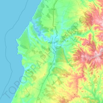
Name: Aljezur topographic map, elevation, terrain.
Location: Aljezur, Faro, Algarve, Portugal (37.21609 -8.87871 37.38380 -8.69818)
Average elevation: 103 m
Minimum elevation: -1 m
Maximum elevation: 364 m
Other topographic maps
Click on a map to view its topography, its elevation and its terrain.
Praia da Amoreira
Praia da Amoreira, EM 1003, Aljezur, AJZ, Faro, Algarve, 8670 156, Portugal
Average elevation: 18 m