
Craven Arms topographic map
Interactive map
Click on the map to display elevation.
About this map
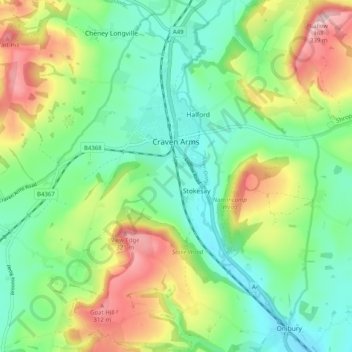
Name: Craven Arms topographic map, elevation, terrain.
Location: Craven Arms, Shropshire, England, United Kingdom (52.40322 -2.87340 52.46416 -2.78925)
Average elevation: 182 m
Minimum elevation: 101 m
Maximum elevation: 335 m
Other topographic maps
Click on a map to view its topography, its elevation and its terrain.
Minton
United Kingdom > England > Shropshire > Church Stretton > Little Stretton
Average elevation: 272 m
Melverley Green
United Kingdom > England > Shropshire > Melverley > Melverley Green
Average elevation: 60 m