
Healy topographic map
Interactive map
Click on the map to display elevation.
About this map
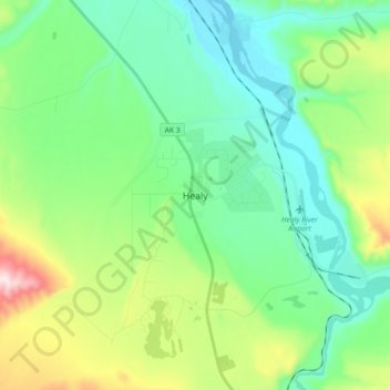
Name: Healy topographic map, elevation, terrain.
Location: Healy, Denali, Alaska, 99743, United States (63.82964 -149.05919 63.90964 -148.97919)
Average elevation: 484 m
Minimum elevation: 355 m
Maximum elevation: 842 m
Other topographic maps
Click on a map to view its topography, its elevation and its terrain.
Cantwell
United States > Alaska > Denali
Cantwell, Denali, Alaska, 99729, United States
Average elevation: 1,104 m
Red Mountain
United States > Alaska > Denali
Red Mountain, Denali, Alaska, United States
Average elevation: 1,708 m