
Thank you for supporting this site ❤️
Make a donation
Make a donation
North Wootton topographic map
Click on the map to display elevation.
Thank you for supporting this site ❤️
Make a donation
Make a donation
About this map
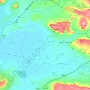
Name: North Wootton topographic map, elevation, terrain.
Location: North Wootton, Somerset, England, United Kingdom (51.15958 -2.69787 51.18523 -2.60223)
Average elevation: 30 m
Minimum elevation: 3 m
Maximum elevation: 130 m
Thank you for supporting this site ❤️
Make a donation
Make a donation
Other topographic maps
Click on a map to view its topography, its elevation and its terrain.
Thorne St Margaret
United Kingdom > England > Somerset > Somerset West and Taunton > Holywell Lake
Average elevation: 94 m