
Bieszczady County topographic map
Interactive map
Click on the map to display elevation.
About this map
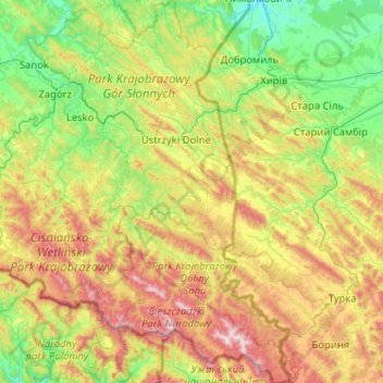
Name: Bieszczady County topographic map, elevation, terrain.
Location: Bieszczady County, Subcarpathian Voivodeship, Poland (49.00205 22.39505 49.67124 22.89409)
Average elevation: 554 m
Minimum elevation: 216 m
Maximum elevation: 1,334 m
Other topographic maps
Click on a map to view its topography, its elevation and its terrain.
Góra Świętej Anny
Poland > Subcarpathian Voivodeship > Jaślany
Góra Świętej Anny, Jaślany, gmina Tuszów Narodowy, powiat mielecki, Subcarpathian Voivodeship, 39-332, Poland
Average elevation: 159 m