
Thank you for supporting this site ❤️
Make a donation
Make a donation
Metelen topographic map
Click on the map to display elevation.
Thank you for supporting this site ❤️
Make a donation
Make a donation
About this map
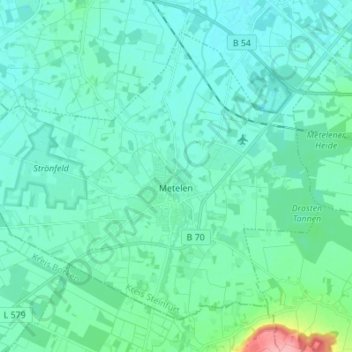
Name: Metelen topographic map, elevation, terrain.
Location: Metelen, Kreis Steinfurt, Noordrijn-Westfalen, 48629, Duitsland (52.11599 7.13523 52.18481 7.27197)
Average elevation: 59 m
Minimum elevation: 44 m
Maximum elevation: 150 m
Thank you for supporting this site ❤️
Make a donation
Make a donation
Other topographic maps
Click on a map to view its topography, its elevation and its terrain.
Isendorf-Beckwermert
Duitsland > Noordrijn-Westfalen > Kreis Steinfurt > Emsdetten
Average elevation: 42 m
Leeden
Duitsland > Noordrijn-Westfalen > Kreis Steinfurt > Tecklenburg > Leeden
Average elevation: 104 m
Thank you for supporting this site ❤️
Make a donation
Make a donation