
Make a donation
Bourne topographic map
Click on the map to display elevation.
Make a donation
About this map
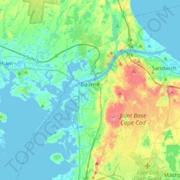
Name: Bourne topographic map, elevation, terrain.
Location: Bourne, Barnstable County, Massachusetts, United States (41.64555 -70.69096 41.82523 -70.44397)
Average elevation: 20 m
Minimum elevation: -5 m
Maximum elevation: 89 m
Make a donation
Other topographic maps
Click on a map to view its topography, its elevation and its terrain.
Opeechee Heights Beach
United States > Massachusetts > Barnstable County > Barnstable > Centerville
Average elevation: 14 m
Make a donation
Make a donation
Bourne Corners
United States > Massachusetts > Barnstable County > Bourne > Buzzards Bay
Average elevation: 9 m
Make a donation
Make a donation
West Barnstable
United States > Massachusetts > Barnstable County > West Barnstable
Average elevation: 15 m
Make a donation
Washburn Island
United States > Massachusetts > Barnstable County > Falmouth > Menauhant
Average elevation: 1 m
Make a donation
Make a donation
Make a donation
Make a donation
Bournedale
United States > Massachusetts > Barnstable County > Bourne > Bournedale
Average elevation: 29 m
Barnstable
United States > Massachusetts > Barnstable County > Barnstable > Barnstable
Average elevation: 10 m
Dennis Port
United States > Massachusetts > Barnstable County > Dennis > Dennis Port
Average elevation: 3 m
Make a donation