
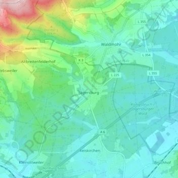
Jägersburg topographic map
Interactive map
Click on the map to display elevation.
About this map
Name: Jägersburg topographic map, elevation, terrain.
Location: Jägersburg, Homburg, Saarpfalz-Kreis, Saarland, Deutschland (49.35762 7.27372 49.38637 7.36934)
Average elevation: 284 m
Minimum elevation: 233 m
Maximum elevation: 477 m
Jägersburg liegt ca. 5 km nordwestlich von Homburg auf einer Höhe von 270 m ü. NHN.
Other topographic maps
Click on a map to view its topography, its elevation and its terrain.
Schwarzenacker
Deutschland > Saarland > Saarpfalz-Kreis > Homburg
Schwarzenacker, Einöd, Homburg, Saarpfalz-Kreis, Saarland, Deutschland
Average elevation: 268 m