
Lao Cai province topographic map
Interactive map
Click on the map to display elevation.
About this map
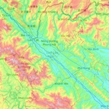
Name: Lao Cai province topographic map, elevation, terrain.
Location: Lao Cai province, Vietnam (21.87581 103.52943 22.84492 104.62866)
Average elevation: 865 m
Minimum elevation: 40 m
Maximum elevation: 3,053 m
There are ten major soil groups under 30 categories in the province, under ten land groups. The land groups are: The Alluvial group (1.47% of the land area) along the Red River is good for growing food crops and trees; the Oxisol type which occupies 40% of land area has generally reddish brown soil, below altitude of 900 metres (3,000 ft), is a fertile land suitable for the annual and commercial crops; Team Red Yellow soil humus covers 30% land area in the Sa Pa, Mường Khương, Bắc Hà, Bát Xát districts of the province suitable for medicinal plants, fruit trees and vegetables; humus soil on the mountain occupies 11.42% of the land area mostly in Sa Pa district which has rich canopy of mixed forest; and the Oxisol color altered by rice in 2% of land area are formed into a landscape of terraced fields, as seen in Bắc Hà and Sa Pa districts.
Other topographic maps
Click on a map to view its topography, its elevation and its terrain.
Ward 2
Vietnam > Soc Trang province > Vĩnh Châu Town
Ward 2, Vĩnh Châu Town, Soc Trang province, Vietnam
Average elevation: 1 m
Tân Lạc District
Tân Lạc District, Hoà Bình province, Vietnam
Average elevation: 416 m
Hoa Lạc
Vietnam > Ha Tinh Province > Thạch Hà District > Hoa Lạc
Hoa Lạc, Thạch Hà District, Ha Tinh Province, 450000, Vietnam
Average elevation: 3 m
Ward 14
Ward 14, Binh Thanh District, 717000, Vietnam
Average elevation: 9 m
Bien Hoa
Vietnam > Dong Nai province > Bien Hoa
Bien Hoa, Bien Hoa City, Dong Nai province, 81000, Vietnam
Average elevation: 24 m
Can Gio District
Can Gio District, Ho Chi Minh City, Vietnam
Average elevation: 2 m
Bố Trạch District
Bố Trạch District, Quảng Bình Province, Vietnam
Average elevation: 356 m
Ho Chi Minh City
Vietnam > Ho Chi Minh City > Ho Chi Minh City
Ho Chi Minh City, District 1, Ho Chi Minh City, 00084, Vietnam
Average elevation: 6 m
Kiến Giang
Vietnam > Quang Binh province > Kiến Giang
Kiến Giang, Lệ Thủy District, Quang Binh province, Vietnam
Average elevation: 3 m
Ngọc Hiển District
Ngọc Hiển District, Cà Mau Province, Vietnam
Average elevation: 1 m
Cần Giờ
Vietnam > Ho Chi Minh City > Ho Chi Minh City > Đông Hòa
Cần Giờ, Đông Hòa, Can Gio District, Ho Chi Minh City, Vietnam
Average elevation: 1 m
Tam Đường District
Tam Đường District, Lai Châu Province, Vietnam
Average elevation: 1,317 m
Kép
Vietnam > Bac Giang Province > Lạng Giang District
Kép, Lạng Giang District, Bắc Giang Province, Vietnam
Average elevation: 25 m
Dalat
Vietnam > Lâm Đồng Province > Dalat
Dalat, Đà Lạt District, Lâm Đồng Province, 67000, Vietnam
Average elevation: 1,360 m