
Thank you for supporting this site ❤️
Make a donation
Make a donation
Loch Lommond topographic map
Click on the map to display elevation.
Thank you for supporting this site ❤️
Make a donation
Make a donation
About this map
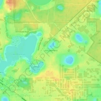
Name: Loch Lommond topographic map, elevation, terrain.
Location: Loch Lommond, Clay County, Florida, 32656, United States (29.78163 -82.03343 29.82163 -81.99343)
Average elevation: 47 m
Minimum elevation: 24 m
Maximum elevation: 68 m
Thank you for supporting this site ❤️
Make a donation
Make a donation
Other topographic maps
Click on a map to view its topography, its elevation and its terrain.
Thank you for supporting this site ❤️
Make a donation
Make a donation
Thank you for supporting this site ❤️
Make a donation
Make a donation
Thank you for supporting this site ❤️
Make a donation
Make a donation