
Greenwood topographic map
Interactive map
Click on the map to display elevation.
About this map
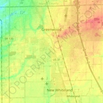
Name: Greenwood topographic map, elevation, terrain.
Location: Greenwood, Johnson County, Indiana, United States (39.54837 -86.16704 39.63693 -86.04000)
Average elevation: 245 m
Minimum elevation: 216 m
Maximum elevation: 270 m
Greenwood's mean elevation is 813 feet (248 m) above sea level. The city's topography is flat to gently rolling.
Other topographic maps
Click on a map to view its topography, its elevation and its terrain.
Johnson County
United States > Indiana > Johnson County
Johnson County, Indiana, United States
Average elevation: 232 m
Banta
United States > Indiana > Johnson County > Bargersville
Banta, Bargersville, Johnson County, Indiana, United States
Average elevation: 232 m