
Make a donation
Gundagai topographic map
Click on the map to display elevation.
Make a donation
Gundagai
Gundagai is an inland town with an elevation of 232 metres (761 ft). Almost all of the shire is located in the South West Slopes bio-region and is part of the Riverina agricultural region. The eastern part of the shire is considered part of the South Eastern Highlands bioregion.
Make a donation
About this map
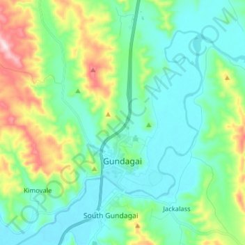
Name: Gundagai topographic map, elevation, terrain.
Average elevation: 309 m
Minimum elevation: 208 m
Maximum elevation: 622 m
Make a donation
Other topographic maps
Click on a map to view its topography, its elevation and its terrain.
Kangaroo Mount
Australia > New South Wales > Cootamundra-Gundagai Regional Council > Gobarralong
Average elevation: 255 m
Burrinjuck Dam
Australia > New South Wales > Cootamundra-Gundagai Regional Council > Wee Jasper > Adjungbilly
Average elevation: 548 m
The Three Sisters
Australia > New South Wales > Cootamundra-Gundagai Regional Council > Cootamundra
Average elevation: 403 m