
Bondville topographic map
Interactive map
Click on the map to display elevation.
About this map
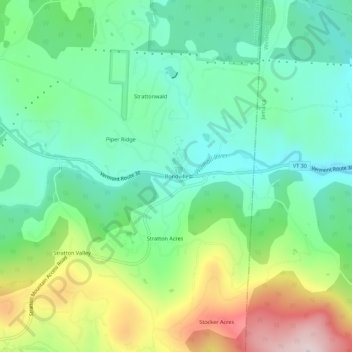
Name: Bondville topographic map, elevation, terrain.
Average elevation: 486 m
Minimum elevation: 354 m
Maximum elevation: 763 m
Other topographic maps
Click on a map to view its topography, its elevation and its terrain.
Stratton Acres
United States > Vermont > Bennington County > Winhall
Stratton Acres, Winhall, Bennington County, Vermont, 05340, United States
Average elevation: 512 m
Gale Meadows Pond
United States > Vermont > Bennington County > Winhall > French Hollow
Gale Meadows Pond, French Hollow, Winhall, Bennington County, Vermont, United States
Average elevation: 437 m