
Michigan City topographic map
Interactive map
Click on the map to display elevation.
About this map
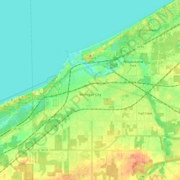
Name: Michigan City topographic map, elevation, terrain.
Location: Michigan City, LaPorte County, Indiana, United States (41.66581 -86.93268 41.75345 -86.81609)
Average elevation: 188 m
Minimum elevation: 172 m
Maximum elevation: 212 m
Other topographic maps
Click on a map to view its topography, its elevation and its terrain.
Springville
United States > Indiana > LaPorte County
Springville, LaPorte County, Indiana, United States
Average elevation: 229 m
Fish Creek
United States > Indiana > LaPorte County > Fish Lake
Fish Creek, Fish Lake, LaPorte County, Indiana, United States
Average elevation: 217 m
Wanatah
United States > Indiana > LaPorte County
Wanatah, LaPorte County, Indiana, 46390, United States
Average elevation: 223 m
Otis
United States > Indiana > LaPorte County
Otis, LaPorte County, Indiana, 46391, United States
Average elevation: 228 m