
Betzdorf topographic map
Interactive map
Click on the map to display elevation.
About this map
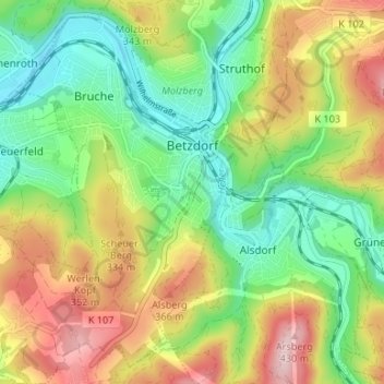
Name: Betzdorf topographic map, elevation, terrain.
Average elevation: 277 m
Minimum elevation: 172 m
Maximum elevation: 429 m
Other topographic maps
Click on a map to view its topography, its elevation and its terrain.
Horhausen (Westerwald)
Deutschland > Rheinland-Pfalz > Landkreis Altenkirchen (Westerwald)
Horhausen (Westerwald), Altenkirchen-Flammersfeld, Landkreis Altenkirchen (Westerwald), Rheinland-Pfalz, Deutschland
Average elevation: 310 m
Forst
Deutschland > Rheinland-Pfalz > Landkreis Altenkirchen (Westerwald)
Forst, Hamm (Sieg), Landkreis Altenkirchen (Westerwald), Rheinland-Pfalz, Deutschland
Average elevation: 253 m
Brachbach
Deutschland > Rheinland-Pfalz > Landkreis Altenkirchen (Westerwald)
Brachbach, Kirchen (Sieg), Landkreis Altenkirchen (Westerwald), Rheinland-Pfalz, Deutschland
Average elevation: 340 m