
Thank you for supporting this site ❤️
Make a donation
Make a donation
Lake Chivero topographic map
Click on the map to display elevation.
Thank you for supporting this site ❤️
Make a donation
Make a donation
About this map
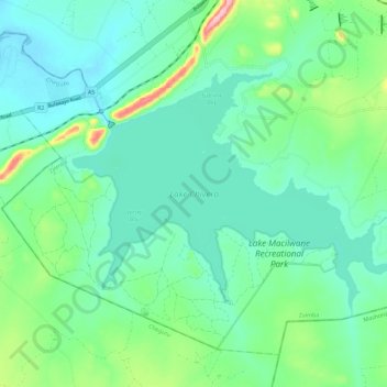
Name: Lake Chivero topographic map, elevation, terrain.
Location: Lake Chivero, Zvimba, Mashonaland West Province, Zimbabwe (-17.93649 30.75809 -17.86842 30.87188)
Average elevation: 1,382 m
Minimum elevation: 1,343 m
Maximum elevation: 1,515 m
Thank you for supporting this site ❤️
Make a donation
Make a donation
Other topographic maps
Click on a map to view its topography, its elevation and its terrain.