
Eggenfelden topographic map
Interactive map
Click on the map to display elevation.
About this map
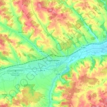
Name: Eggenfelden topographic map, elevation, terrain.
Location: Eggenfelden, Landkreis Rottal-Inn, Bavière, 84307, Allemagne (48.36985 12.69863 48.44634 12.79913)
Average elevation: 440 m
Minimum elevation: 392 m
Maximum elevation: 494 m
Other topographic maps
Click on a map to view its topography, its elevation and its terrain.
Ferlin
Allemagne > Bavière > Landkreis Rottal-Inn > Hebertsfelden
Ferlin, Hebertsfelden, Landkreis Rottal-Inn, Bavière, 84332, Allemagne
Average elevation: 438 m
Pfarrkirchen
Allemagne > Bavière > Landkreis Rottal-Inn > Pfarrkirchen
Pfarrkirchen, Landkreis Rottal-Inn, Bavière, 84347, Allemagne
Average elevation: 429 m
Bürchen
Allemagne > Bavière > Landkreis Rottal-Inn > Zell
Bürchen, Zell, Falkenberg, Falkenberg (VGem), Landkreis Rottal-Inn, Bavière, 84333, Allemagne
Average elevation: 446 m