
Scharnitz topographic map
Interactive map
Click on the map to display elevation.
About this map
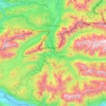
Name: Scharnitz topographic map, elevation, terrain.
Location: Scharnitz, Bezirk Innsbruck-Land, 6108, Autriche (47.32657 11.20996 47.44992 11.52211)
Average elevation: 1,448 m
Minimum elevation: 603 m
Maximum elevation: 2,671 m
Other topographic maps
Click on a map to view its topography, its elevation and its terrain.
Plöven
Autriche > Bezirk Innsbruck-Land > Fulpmes
Plöven, Fulpmes, Bezirk Innsbruck-Land, 6165, Autriche
Average elevation: 1,297 m