
Thank you for supporting this site ❤️
Make a donation
Make a donation
Lembongan Island topographic map
Click on the map to display elevation.
Thank you for supporting this site ❤️
Make a donation
Make a donation
About this map
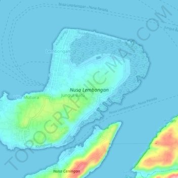
Name: Lembongan Island topographic map, elevation, terrain.
Location: Lembongan Island, Jungutbatu, Bali, Indonesia (-8.69452 115.42698 -8.66313 115.47312)
Average elevation: 13 m
Minimum elevation: -1 m
Maximum elevation: 125 m
Thank you for supporting this site ❤️
Make a donation
Make a donation
Other topographic maps
Click on a map to view its topography, its elevation and its terrain.