
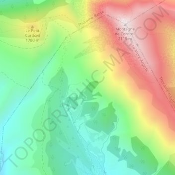
Ruisseau du ravin de Prariou topographic map
Interactive map
Click on the map to display elevation.
About this map
Name: Ruisseau du ravin de Prariou topographic map, elevation, terrain.
Average elevation: 1,629 m
Minimum elevation: 1,298 m
Maximum elevation: 2,107 m
Other topographic maps
Click on a map to view its topography, its elevation and its terrain.
La Mure
France > Provence-Alpes-Côte d'Azur > Alpes-de-Haute-Provence > La Mure-Argens
La Mure, La Mure-Argens, Castellane, Alpes-de-Haute-Provence, Provence-Alpes-Côte d'Azur, France métropolitaine, 04170, France
Average elevation: 1,191 m
Argens
France > Provence-Alpes-Côte d'Azur > Alpes-de-Haute-Provence > La Mure-Argens
Argens, La Mure-Argens, Castellane, Alpes-de-Haute-Provence, Provence-Alpes-Côte d'Azur, France métropolitaine, 04170, France
Average elevation: 1,484 m
La Mure
France > Provence-Alpes-Côte d'Azur > Alpes-de-Haute-Provence > La Mure-Argens > La Mure
La Mure, La Mure-Argens, Castellane, Alpes-de-Haute-Provence, Provence-Alpes-Côte d'Azur, France métropolitaine, 04170, France
Average elevation: 1,071 m