
Thank you for supporting this site ❤️
Make a donation
Make a donation
Inga topographic map
Click on the map to display elevation.
Thank you for supporting this site ❤️
Make a donation
Make a donation
About this map
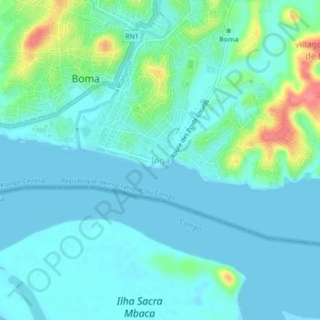
Name: Inga topographic map, elevation, terrain.
Location: Inga, Boma, Kongo-Central, Democratic Republic of the Congo (-5.88017 13.03939 -5.84017 13.07939)
Average elevation: 15 m
Minimum elevation: -2 m
Maximum elevation: 77 m
Thank you for supporting this site ❤️
Make a donation
Make a donation