
Guayaquil topographic map
Interactive map
Click on the map to display elevation.
About this map
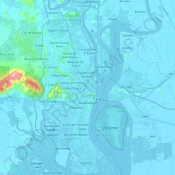
Name: Guayaquil topographic map, elevation, terrain.
Location: Guayaquil, Guayas, Ecuador (-2.28757 -79.95912 -2.05291 -79.85635)
Average elevation: 17 m
Minimum elevation: -6 m
Maximum elevation: 459 m
Guayaquil liegt am Westufer des Río Guayas, etwa 50 km oberhalb von dessen Mündung in den Golf von Guayaquil. Der Río Guayas ist ein in Guayaquil liegender Zusammenfluss des Río Daule und des Río Babahoyo. Das ursprüngliche Zentrum von Guayaquil liegt auf geringer Höhe zwischen drei Hügeln und dem Estero Salado (spanisch für „salziger Sumpf“), einem weit ins Landesinnere ragenden Meeresarm, der im heutigen Stadtgebiet zum Teil ausgetrocknet und u. a. mit gehobenen Wohnvierteln bebaut worden ist.
Other topographic maps
Click on a map to view its topography, its elevation and its terrain.
Socio Vivienda 3
Ecuador > Guayas > Guayaquil > Guayaquil
Socio Vivienda 3, Guayaquil, Guayas, 090804, Ecuador
Average elevation: 100 m