
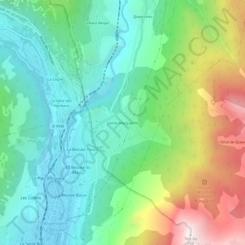
Sainte-Marguerite topographic map
Interactive map
Click on the map to display elevation.
About this map
Name: Sainte-Marguerite topographic map, elevation, terrain.
Average elevation: 1,453 m
Minimum elevation: 970 m
Maximum elevation: 2,518 m
Other topographic maps
Click on a map to view its topography, its elevation and its terrain.
Ratière
France > Provence-Alpes-Côte d'Azur > Hautes-Alpes > Saint-Martin-de-Queyrières
Ratière, Saint-Martin-de-Queyrières, Briançon, Hautes-Alpes, Provence-Alpes-Côte d'Azur, France métropolitaine, 05120, France
Average elevation: 1,723 m
Roche Baron
France > Provence-Alpes-Côte d'Azur > Hautes-Alpes > Saint-Martin-de-Queyrières
Roche Baron, Saint-Martin-de-Queyrières, Briançon, Hautes-Alpes, Provence-Alpes-Côte d'Azur, France métropolitaine, 05120, France
Average elevation: 1,512 m
La Salcette
France > Provence-Alpes-Côte d'Azur > Hautes-Alpes > Saint-Martin-de-Queyrières
La Salcette, Saint-Martin-de-Queyrières, Briançon, Hautes-Alpes, Provence-Alpes-Côte d'Azur, France métropolitaine, 05120, France
Average elevation: 1,834 m