
Town/Village of East Rochester topographic map
Interactive map
Click on the map to display elevation.
About this map
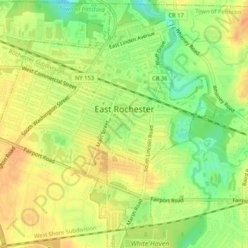
Name: Town/Village of East Rochester topographic map, elevation, terrain.
Average elevation: 128 m
Minimum elevation: 105 m
Maximum elevation: 144 m
Other topographic maps
Click on a map to view its topography, its elevation and its terrain.
City of Rochester
United States > New York > Monroe County > City of Rochester
City of Rochester, Monroe County, New York, United States
Average elevation: 129 m