
Thank you for supporting this site ❤️
Make a donation
Make a donation
Waterford topographic map
Click on the map to display elevation.
Thank you for supporting this site ❤️
Make a donation
Make a donation
Waterford
The city was founded around the Tuolumne River. City population signs report Waterford's elevation is 51 feet (16 m) above sea level.
Thank you for supporting this site ❤️
Make a donation
Make a donation
About this map
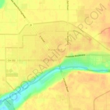
Name: Waterford topographic map, elevation, terrain.
Location: Waterford, Stanislaus County, California, United States (37.62990 -120.77866 37.64962 -120.73859)
Average elevation: 49 m
Minimum elevation: 20 m
Maximum elevation: 61 m
Thank you for supporting this site ❤️
Make a donation
Make a donation
Other topographic maps
Click on a map to view its topography, its elevation and its terrain.