
Lukla topographic map
Interactive map
Click on the map to display elevation.
About this map
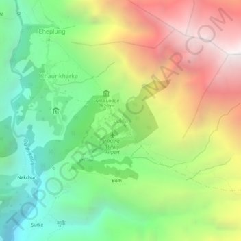
Name: Lukla topographic map, elevation, terrain.
Location: Lukla, Khumbupasanglahmu, सोलुखुम्बु, कोशी प्रदेश, Nepal (27.66897 86.71067 27.70897 86.75067)
Average elevation: 2,996 m
Minimum elevation: 1,969 m
Maximum elevation: 4,436 m
Lukla é uma cidade no nordeste do Nepal situada a 2860 metros de altitude. É um lugar muito popular entre os montanhistas por ser o único acesso para quem quer visitar esta parte da Cordilheira do Himalaia. Nesta região estão as montanhas mais altas do planeta, incluindo o monte Everest.
Other topographic maps
Click on a map to view its topography, its elevation and its terrain.
Namche Bazar
Nepal > सोलुखुम्बु > Namche
Namche Bazar, Namche, Khumbupasanglahmu, सोलुखुम्बु, कोशी प्रदेश, 56002, Nepal
Average elevation: 3,526 m
Gokyo Ri
Nepal > सोलुखुम्बु > Khumjung
Gokyo Ri, Khumjung, Khumbupasanglahmu, सोलुखुम्बु, Province #1, Nepal
Average elevation: 4,968 m
Chukhung
Nepal > सोलुखुम्बु > Chukhung
Chukhung, Khumjung, Khumbupasanglahmu, सोलुखुम्बु, Province #1, Nepal
Average elevation: 4,918 m
Namche
Namche, Khumbupasanglahmu, सोलुखुम्बु, Province #1, 56000, Nepal
Average elevation: 5,230 m