
Thank you for supporting this site ❤️
Make a donation
Make a donation
Jerudong topographic map
Click on the map to display elevation.
Thank you for supporting this site ❤️
Make a donation
Make a donation
About this map
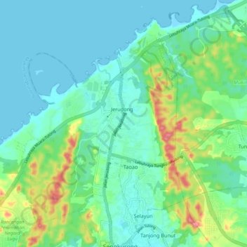
Name: Jerudong topographic map, elevation, terrain.
Location: Jerudong, Mukim Sengkurong, Brunei-Muara District, Brunei (4.89184 114.77642 4.97312 114.86724)
Average elevation: 26 m
Minimum elevation: -3 m
Maximum elevation: 106 m
Thank you for supporting this site ❤️
Make a donation
Make a donation
Other topographic maps
Click on a map to view its topography, its elevation and its terrain.