
Make a donation
Malappuram topographic map
Click on the map to display elevation.
Make a donation
Malappuram
Bounded by Kozhikode district to the northwest, Wayanad district to the northeast, Nilgiri hills to the east, Palakkad district to the southeast, Thrissur district to the southwest, and Arabian Sea to the west, Malappuram has a total geographical area of 3,554 km2, which ranks third in the state in terms of area. The district possesses 9.15% of the total area of the state. The district is located at 75°E – 77°E longitude and 10°N – 12°N latitude on the geographical map. Similar to other parts of Kerala, Malappuram also has a coastal area (lowland) bounded by Arabian Sea on the west, a midland at the centre, and a hilly area (highland), bounded by Western Ghats on the east. Unlike other districts of Kerala, hilly areas are widely seen in the midland area too. The 2,554 m high Mukurthi peak, which is situated in the border of Nilambur Taluk and Ooty Taluk, and is also the fifth-highest peak in South India as well as the third-highest in Kerala after Anamudi (2,696 m) and Meesapulimala (2,651 m), is the highest point of elevation in Malappuram district. It is also the highest peak in Kerala outside the Idukki district. The 2,383 high Anginda peak, which is located closer to Malappuram-Palakkad-Nilgiris district border is the second-highest peak. Vavul Mala, a 2,339 m high peak situated on the trijunction of Nilambur Taluk of Malappuram, Wayanad, and Thamarassery Taluk of Kozhikode districts, is the third-highest point of elevation in the district.
Make a donation
About this map
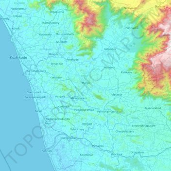
Name: Malappuram topographic map, elevation, terrain.
Location: Malappuram, Kerala, India (10.68412 75.82560 11.52928 76.54997)
Average elevation: 224 m
Minimum elevation: -5 m
Maximum elevation: 2,529 m
Make a donation
Other topographic maps
Click on a map to view its topography, its elevation and its terrain.
Thiruvananthapuram
India > Kerala > Thiruvananthapuram
Thiruvananthapuram is built on seven hills by the seashore and is at 8°30′N 76°54′E / 8.5°N 76.9°E / 8.5; 76.9 on the west coast, near the southern tip of mainland India. The city is on the west coast of India and is bounded by the Laccadive Sea to its west and the Western Ghats to its east.…
Average elevation: 33 m
Kannur
Kannur has an elevation of 1.02 metres or 3.3 feet along the coast of the Laccadive Sea, with a sandy coastal area. The city has an 8 kilometres (5.0 miles)-long seashore and a 3 kilometres (1.9 miles)-long beach at Payyambalam. Kannur is located north of Kozhikode, south of Kasargod and Mangalore, west of the…
Average elevation: 14 m
Make a donation