
San Andrés Xecul topographic map
Interactive map
Click on the map to display elevation.
About this map
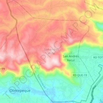
Name: San Andrés Xecul topographic map, elevation, terrain.
Location: San Andrés Xecul, Totonicapán, Guatemala (14.87761 -91.52267 14.93934 -91.46863)
Average elevation: 2,586 m
Minimum elevation: 2,330 m
Maximum elevation: 2,858 m
Other topographic maps
Click on a map to view its topography, its elevation and its terrain.
Santa Lucía la Reforma
Guatemala > Totonicapán > Santa Lucía La Reforma
Santa Lucía la Reforma, Santa Lucía La Reforma, Totonicapán, Guatemala
Average elevation: 1,860 m
San Cristóbal Totonicapán
San Cristóbal Totonicapán, Totonicapán, Guatemala
Average elevation: 2,561 m
San Francisco El Alto
San Francisco El Alto, Totonicapán, Guatemala
Average elevation: 2,671 m
Santa Lucía La Reforma
Santa Lucía La Reforma, Totonicapán, Guatemala
Average elevation: 1,808 m