
Pincourt topographic map
Interactive map
Click on the map to display elevation.
About this map
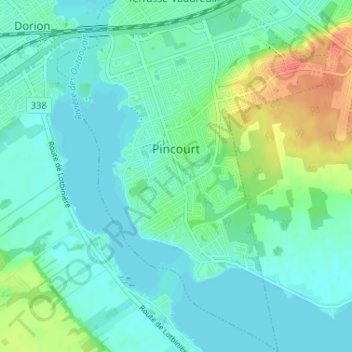
Name: Pincourt topographic map, elevation, terrain.
Location: Pincourt, Vaudreuil-Soulanges, Montérégie, Québec, Canada (45.34490 -74.00802 45.39046 -73.95814)
Average elevation: 31 m
Minimum elevation: 19 m
Maximum elevation: 65 m
Other topographic maps
Click on a map to view its topography, its elevation and its terrain.
Notre-Dame-de-l'Île-Perrot
Canada > Québec > Vaudreuil-Soulanges > Notre-Dame-de-l'Île-Perrot
Notre-Dame-de-l'Île-Perrot, Vaudreuil-Soulanges, Montérégie, Québec, Canada
Average elevation: 26 m