
Thank you for supporting this site ❤️
Make a donation
Make a donation
Panton topographic map
Click on the map to display elevation.
Thank you for supporting this site ❤️
Make a donation
Make a donation
About this map
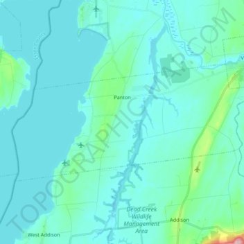
Name: Panton topographic map, elevation, terrain.
Location: Panton, Addison County, Vermont, 05491, United States (44.10784 -73.41578 44.16526 -73.24998)
Average elevation: 42 m
Minimum elevation: 24 m
Maximum elevation: 203 m
Thank you for supporting this site ❤️
Make a donation
Make a donation
Other topographic maps
Click on a map to view its topography, its elevation and its terrain.
Abbey Pond Cascades (lower)
United States > Vermont > Addison County > Middlebury
Average elevation: 305 m
Thank you for supporting this site ❤️
Make a donation
Make a donation
Lake Dunmore
United States > Vermont > Addison County > Salisbury > Lake Dunmore
Average elevation: 192 m
Thank you for supporting this site ❤️
Make a donation
Make a donation