
Νέα Χηλή topographic map
Interactive map
Click on the map to display elevation.
About this map
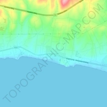
Name: Νέα Χηλή topographic map, elevation, terrain.
Average elevation: 27 m
Minimum elevation: -2 m
Maximum elevation: 141 m
Other topographic maps
Click on a map to view its topography, its elevation and its terrain.
Sterna
Grèce > Macédoine-Thrace > Nome de l'Évros
Sterna, Δήμος Ορεστιάδας, Nome de l'Évros, Macédoine-Orientale-et-Thrace, Macédoine-Thrace, 682 00, Grèce
Average elevation: 77 m