
Make a donation
Jiangsu topographic map
Click on the map to display elevation.
Make a donation
Jiangsu
Jiangsu is flat, with plains covering 68 percent of its total area (water covers another 18 percent). Most of the province stands not more than 50 meters (160 ft) above sea level. Jiangsu also has a well-developed irrigation system, which earned it (especially the southern half) the moniker of traditional Chinese: 水鄕; simplified Chinese: 水乡 (shuǐxiāng "land of water"). The southern city of Suzhou has so many canals that it has been dubbed "Venice of the East" or the "Venice of the Orient." The Grand Canal of China cuts through Jiangsu from north to south, crossing all the east–west river systems. Jiangsu also borders the Yellow Sea. The Yangtze River, the longest river of China, cuts through the province in the south and reaches the East China Sea, which divides the region into two parts: more urban, prosperous south and more poorer, rural north, and these two parts has a tense division. Mount Huaguo, near the city of Lianyungang, is the highest point in Jiangsu, at an altitude of 625 meters (2,051 ft) above sea level. Large lakes in Jiangsu include Lake Tai (the largest), Lake Hongze, Lake Gaoyou, Lake Luoma, and Lake Yangcheng.
Make a donation
About this map
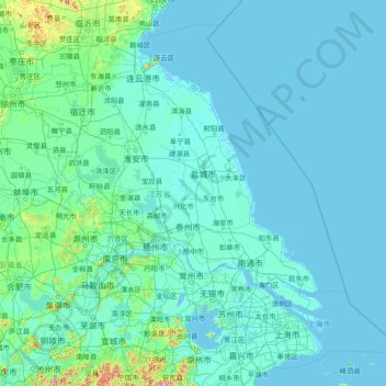
Name: Jiangsu topographic map, elevation, terrain.
Location: Jiangsu, China (30.76033 116.35520 35.16667 122.38666)
Average elevation: 24 m
Minimum elevation: -3 m
Maximum elevation: 1,144 m
Make a donation
Other topographic maps
Click on a map to view its topography, its elevation and its terrain.
Jade Dragon Snow Mountain
China > Yunnan > Lijiang City
The view of the massif from the gardens at the Black Dragon Pool (Heilong Tan) in Lijiang is noted as one of China's finest views. The mountain is part of Yulong Snow Mountain National Scenic Area and National Geological Park, an AAAAA-classified scenic area. The Park operates a tourist cable car that climbs…
Average elevation: 4,829 m
Shanghai
The golden age of Shanghai began with its elevation to municipality after it was separated from Jiangsu on 7 July 1927. This new Chinese municipality covered an area of 494.69 km2 (191.0 sq mi), including the modern-day districts of Baoshan, Yangpu, Zhabei, Nanshi, and Pudong, but excluded the foreign…
Average elevation: 5 m
Make a donation
Make a donation
Make a donation