
Ľubietová topographic map
Interactive map
Click on the map to display elevation.
About this map
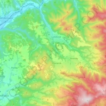
Name: Ľubietová topographic map, elevation, terrain.
Average elevation: 683 m
Minimum elevation: 366 m
Maximum elevation: 1,282 m
Ľubietová is part of the Banská Bystrica District in the Banská Bystrica Region. It is situated 25 km east from the town of Banská Bystrica. It lies at an altitude of 491 metres and covers an area of 61 km². The geographic center of Slovakia, the Hrb mountain, is located near the village.