
Mrągowo County topographic map
Interactive map
Click on the map to display elevation.
About this map
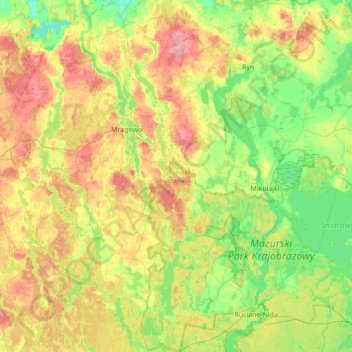
Name: Mrągowo County topographic map, elevation, terrain.
Location: Mrągowo County, Warmian-Masurian Voivodeship, Poland (53.62551 21.05137 53.99622 21.74382)
Average elevation: 141 m
Minimum elevation: 98 m
Maximum elevation: 214 m
Other topographic maps
Click on a map to view its topography, its elevation and its terrain.
Przystań
Poland > Warmian-Masurian Voivodeship > Przystań
Przystań, gmina Węgorzewo, powiat węgorzewski, Warmian-Masurian Voivodeship, 11-600, Poland
Average elevation: 121 m
Olsztynek
Poland > Warmian-Masurian Voivodeship > Olsztynek
Olsztynek, gmina Olsztynek, powiat olsztyński, Warmian-Masurian Voivodeship, 11-015, Poland
Average elevation: 174 m
Mrągowo
Poland > Warmian-Masurian Voivodeship > Mrągowo
Mrągowo, powiat mrągowski, Warmian-Masurian Voivodeship, 11-700, Poland
Average elevation: 150 m
Gryżyna
Poland > Warmian-Masurian Voivodeship > Elbląg County
Gryżyna, gmina Pasłęk, Elbląg County, Warmian-Masurian Voivodeship, 14-400, Poland
Average elevation: 73 m