
Thank you for supporting this site ❤️
Make a donation
Make a donation
Clarksville topographic map
Click on the map to display elevation.
Thank you for supporting this site ❤️
Make a donation
Make a donation
About this map
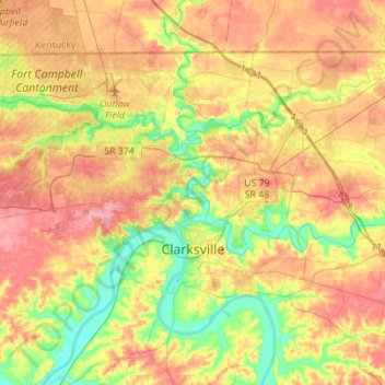
Name: Clarksville topographic map, elevation, terrain.
Average elevation: 155 m
Minimum elevation: 108 m
Maximum elevation: 200 m
Thank you for supporting this site ❤️
Make a donation
Make a donation
Other topographic maps
Click on a map to view its topography, its elevation and its terrain.
Thank you for supporting this site ❤️
Make a donation
Make a donation
Evergreen Estates
United States > Tennessee > Montgomery County > Clarksville
Average elevation: 147 m
Thank you for supporting this site ❤️
Make a donation
Make a donation
Thank you for supporting this site ❤️
Make a donation
Make a donation