
Make a donation
Katowice topographic map
Click on the map to display elevation.
Make a donation
Katowice
Katowice encompasses an area of 164.67 square kilometres (63.58 sq mi). The city is situated in the Silesian Highlands, about 50 km (31 mi) north of the Silesian Beskids (part of the Carpathian Mountains). Kłodnica and Rawa (tributaries of the Oder and the Vistula respectively) are the largest rivers in Katowice, and the border between catchment areas of Oder and Vistula goes through the city. With a minimal elevation of 245 metres (804 ft) and median elevation of 266 metres (873 ft) above sea level, Katowice has the highest elevation among large cities in Poland.
Make a donation
About this map
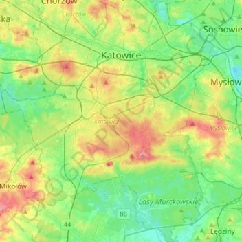
Name: Katowice topographic map, elevation, terrain.
Location: Katowice, Metropolis GZM, Silesian Voivodeship, Poland (50.13006 18.89154 50.29769 19.12442)
Average elevation: 275 m
Minimum elevation: 236 m
Maximum elevation: 351 m
Make a donation